


Aureille - GR6 - Eygalières

Berpav
User
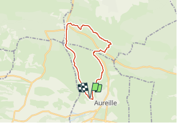

Length
13.1 km

Max alt
305 m

Uphill gradient
332 m
Km-Effort
17.6 km

Min alt
149 m

Downhill gradient
334 m
Boucle
Yes
Creation date :
2021-11-06 15:45:52.518
Updated on :
2021-11-06 15:46:25.657
3h59
Difficulty : Difficult

FREE GPS app for hiking
 SityTrail
IGN / Geographical institutes
SityTrail Plus
The world is yours!
About
Trail Walking of 13.1 km to be discovered at Provence-Alpes-Côte d'Azur, Bouches-du-Rhône, Aureille. This trail is proposed by Berpav.
Positioning
Country:
France
Region :
Provence-Alpes-Côte d'Azur
Department/Province :
Bouches-du-Rhône
Municipality :
Aureille
Location:
Unknown
Start:(Dec)
Start:(UTM)
656050 ; 4841406 (31T) N.
Comments