


Saint-Pancré la cusignère

veroberton
User
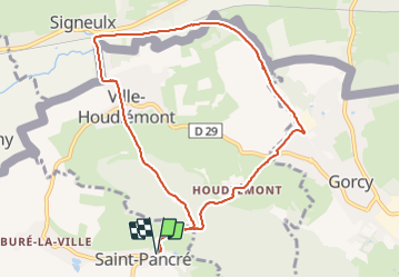

Length
8.9 km

Max alt
401 m

Uphill gradient
289 m
Km-Effort
12.7 km

Min alt
224 m

Downhill gradient
289 m
Boucle
Yes
Creation date :
2021-11-08 12:43:29.719
Updated on :
2021-11-08 15:15:41.14
2h31
Difficulty : Medium

FREE GPS app for hiking
 SityTrail
IGN / Geographical institutes
SityTrail Plus
The world is yours!
About
Trail Walking of 8.9 km to be discovered at Grand Est, Meurthe-et-Moselle, Saint-Pancré. This trail is proposed by veroberton.
Positioning
Country:
France
Region :
Grand Est
Department/Province :
Meurthe-et-Moselle
Municipality :
Saint-Pancré
Location:
Unknown
Start:(Dec)
Start:(UTM)
691894 ; 5489708 (31U) N.
Comments