


Pla de Lalau (Maison du Valier)-Mont Valier (Refuge des Etstagnous)

ARVIEU
User
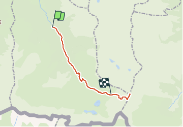

Length
10.7 km

Max alt
2809 m

Uphill gradient
1859 m
Km-Effort
31 km

Min alt
946 m

Downhill gradient
560 m
Boucle
No
Creation date :
2021-11-08 16:25:53.157
Updated on :
2021-11-08 16:30:19.306
7h05
Difficulty : Very difficult

FREE GPS app for hiking
 SityTrail
IGN / Geographical institutes
SityTrail Plus
The world is yours!
About
Trail Walking of 10.7 km to be discovered at Occitania, Ariège, Bordes-Uchentein. This trail is proposed by ARVIEU.
Positioning
Country:
France
Region :
Occitania
Department/Province :
Ariège
Municipality :
Bordes-Uchentein
Location:
Les Bordes-sur-Lez
Start:(Dec)
Start:(UTM)
339229 ; 4743897 (31T) N.
Comments