


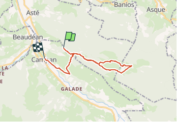
casque du Lheris en boucle depuis Campan

Prala
User

Length
13 km

Max alt
1577 m

Uphill gradient
597 m
Km-Effort
23 km

Min alt
656 m

Downhill gradient
1111 m
Boucle
No
Creation date :
2021-11-10 10:09:13.737
Updated on :
2021-11-10 16:17:20.345
6h06
Difficulty : Medium

FREE GPS app for hiking
 SityTrail
IGN / Geographical institutes
SityTrail Plus
The world is yours!
About
Trail Walking of 13 km to be discovered at Occitania, Hautespyrenees, Asté. This trail is proposed by Prala.
Positioning
Country:
France
Region :
Occitania
Department/Province :
Hautespyrenees
Municipality :
Asté
Location:
Unknown
Start:(Dec)
Start:(UTM)
271139 ; 4767247 (31T) N.
Comments