


trois fours

jcschubnel
User
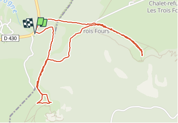

Length
2.9 km

Max alt
1272 m

Uphill gradient
64 m
Km-Effort
3.7 km

Min alt
1197 m

Downhill gradient
65 m
Boucle
Yes
Creation date :
2021-11-11 08:52:35.368
Updated on :
2021-11-11 12:21:26.106
2h00
Difficulty : Easy

FREE GPS app for hiking
 SityTrail
IGN / Geographical institutes
SityTrail Plus
The world is yours!
About
Trail Walking of 2.9 km to be discovered at Grand Est, Vosges, Xonrupt-Longemer. This trail is proposed by jcschubnel.
Positioning
Country:
France
Region :
Grand Est
Department/Province :
Vosges
Municipality :
Xonrupt-Longemer
Location:
Unknown
Start:(Dec)
Start:(UTM)
352024 ; 5323890 (32U) N.
Comments