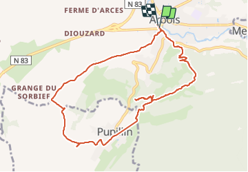
Trail Walking Arbois - arbois - Photo
© OpenStreetMap contributors
Length
Length
10.1 km
Max alt
Max alt
502 m
Uphill gradient
Uphill gradient
335 m
Km-Effort
Km-Effort  
14.6 km
Min alt
Min alt
292 m
Downhill gradient
Downhill gradient
334 m
Boucle
Boucle
Yes
Creation date :
2021-11-11 09:50:38.934
Updated on :
2021-11-12 18:25:46.71

(0 Reviews)

Walking
Walking
3h10
Difficulty : Very easy

Scan this QR Code to open this trail in the SityTrail application

FREE GPS app for hiking

Logo SityTrail SityTrail

IGN / Geographical institutes

Download SityTrail from the App Store Download SityTrail from Google Play

Logo SityTrail SityTrail Plus

The world is yours!

Download SityTrail from the App Store Download SityTrail from Google Play Download SityTrail on Huawei AppGallery

About

Trail Walking of 10.1 km to be discovered at Bourgogne-Franche-Comté, Jura, Arbois. This trail is proposed by eltonnermou.

Description

belle randonnée à travers une première grande partie à travers les vignes et prairie sur chemin (route) goudronnée ; quelques points de vue, qui mérite de passer un peu de temps. Arrivé à Pupillin, sur réservation, vous pouvez déjeuner au Grapiot (très excellent). Le retour sur Arbois se fait à travers bois, cheminement agréable sur l'allée du roy ; le point de vue et la chapelle de l'ermitage concluent cette randonnée.

Elevation profile

Positioning

Country:
France
Region :
Bourgogne-Franche-Comté
Department/Province :
Jura
Municipality :
Arbois
Location:
Unknown
Start:(UTM)
711075 ; 5197986 (31T) N.


Close
My subscriptions