


pas des voutes et allier

BELLETGE
User
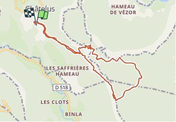

Length
10.6 km

Max alt
1315 m

Uphill gradient
942 m
Km-Effort
23 km

Min alt
558 m

Downhill gradient
934 m
Boucle
Yes
Creation date :
2021-11-13 09:20:13.155
Updated on :
2021-11-13 16:22:47.098
3h35
Difficulty : Difficult

FREE GPS app for hiking
 SityTrail
IGN / Geographical institutes
SityTrail Plus
The world is yours!
About
Trail Walking of 10.6 km to be discovered at Auvergne-Rhône-Alpes, Isère, Châtelus. This trail is proposed by BELLETGE.
Positioning
Country:
France
Region :
Auvergne-Rhône-Alpes
Department/Province :
Isère
Municipality :
Châtelus
Location:
Unknown
Start:(Dec)
Start:(UTM)
686780 ; 4991441 (31T) N.
Comments