


mayons

sacadostcv
User
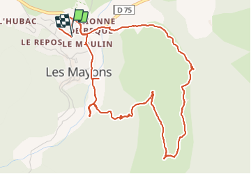

Length
7.1 km

Max alt
294 m

Uphill gradient
202 m
Km-Effort
9.7 km

Min alt
132 m

Downhill gradient
200 m
Boucle
Yes
Creation date :
2021-11-14 08:35:39.726
Updated on :
2021-11-14 11:30:20.026
2h06
Difficulty : Medium

FREE GPS app for hiking
 SityTrail
IGN / Geographical institutes
SityTrail Plus
The world is yours!
About
Trail Walking of 7.1 km to be discovered at Provence-Alpes-Côte d'Azur, Var, Les Mayons. This trail is proposed by sacadostcv.
Positioning
Country:
France
Region :
Provence-Alpes-Côte d'Azur
Department/Province :
Var
Municipality :
Les Mayons
Location:
Unknown
Start:(Dec)
Start:(UTM)
285774 ; 4799375 (32T) N.
Comments