


Segment 26 ème SR

supercolas
User GUIDE
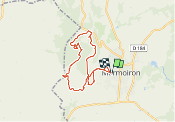

Length
8.5 km

Max alt
369 m

Uphill gradient
243 m
Km-Effort
11.7 km

Min alt
245 m

Downhill gradient
240 m
Boucle
Yes
Creation date :
2021-11-14 11:46:14.523
Updated on :
2021-11-14 14:12:37.183
2h12
Difficulty : Medium

FREE GPS app for hiking
 SityTrail
IGN / Geographical institutes
SityTrail Plus
The world is yours!
About
Trail Walking of 8.5 km to be discovered at Provence-Alpes-Côte d'Azur, Vaucluse, Mormoiron. This trail is proposed by supercolas.
Description
Mormoiron
Photos


Positioning
Country:
France
Region :
Provence-Alpes-Côte d'Azur
Department/Province :
Vaucluse
Municipality :
Mormoiron
Location:
Unknown
Start:(Dec)
Start:(UTM)
674586 ; 4881622 (31T) N.
Comments