


Rando Fontainebleau MN RP 8,8 km

jeanmarcMasson
User GUIDE
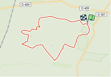

Length
8.8 km

Max alt
145 m

Uphill gradient
88 m
Km-Effort
10 km

Min alt
89 m

Downhill gradient
90 m
Boucle
Yes
Creation date :
2021-11-14 13:10:31.883
Updated on :
2021-11-14 15:29:13.682
2h02
Difficulty : Medium

FREE GPS app for hiking
 SityTrail
IGN / Geographical institutes
SityTrail Plus
The world is yours!
About
Trail Walking of 8.8 km to be discovered at Ile-de-France, Seine-et-Marne, Fontainebleau. This trail is proposed by jeanmarcMasson.
Positioning
Country:
France
Region :
Ile-de-France
Department/Province :
Seine-et-Marne
Municipality :
Fontainebleau
Location:
Unknown
Start:(Dec)
Start:(UTM)
472987 ; 5361789 (31U) N.
Comments