


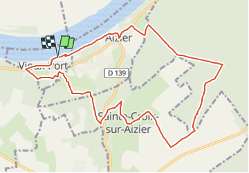
Vieux Port à Aizier

JMCMoreau
User

Length
11 km

Max alt
124 m

Uphill gradient
229 m
Km-Effort
14 km

Min alt
0 m

Downhill gradient
227 m
Boucle
Yes
Creation date :
2021-11-16 08:30:45.061
Updated on :
2021-11-16 08:34:01.39
3h30
Difficulty : Easy

FREE GPS app for hiking
 SityTrail
IGN / Geographical institutes
SityTrail Plus
The world is yours!
About
Trail Walking of 11 km to be discovered at Normandy, Eure, Vieux-Port. This trail is proposed by JMCMoreau.
Positioning
Country:
France
Region :
Normandy
Department/Province :
Eure
Municipality :
Vieux-Port
Location:
Unknown
Start:(Dec)
Start:(UTM)
326809 ; 5477702 (31U) N.
Comments