


SityTrail - Le Chemin de César à Bugard M1

mitch1952
User
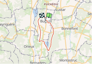

Length
10.2 km

Max alt
475 m

Uphill gradient
210 m
Km-Effort
13 km

Min alt
347 m

Downhill gradient
211 m
Boucle
Yes
Creation date :
2021-11-17 10:44:24.017
Updated on :
2021-11-17 16:27:06.668
2h57
Difficulty : Easy

FREE GPS app for hiking
 SityTrail
IGN / Geographical institutes
SityTrail Plus
The world is yours!
About
Trail On foot of 10.2 km to be discovered at Occitania, Hautespyrenees, Bugard. This trail is proposed by mitch1952.
Points of interest


Positioning
Country:
France
Region :
Occitania
Department/Province :
Hautespyrenees
Municipality :
Bugard
Location:
Unknown
Start:(Dec)
Start:(UTM)
281989 ; 4792886 (31T) N.
Comments