


pruniers

lecmic
User
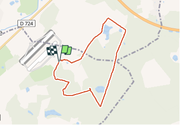

Length
7.5 km

Max alt
112 m

Uphill gradient
56 m
Km-Effort
8.2 km

Min alt
90 m

Downhill gradient
53 m
Boucle
Yes
Creation date :
2021-11-17 12:47:34.94
Updated on :
2021-11-17 15:10:08.559
2h04
Difficulty : Easy

FREE GPS app for hiking
 SityTrail
IGN / Geographical institutes
SityTrail Plus
The world is yours!
About
Trail Walking of 7.5 km to be discovered at Centre-Loire Valley, Loir-et-Cher, Gièvres. This trail is proposed by lecmic.
Description
rando douce
Positioning
Country:
France
Region :
Centre-Loire Valley
Department/Province :
Loir-et-Cher
Municipality :
Gièvres
Location:
Unknown
Start:(Dec)
Start:(UTM)
401585 ; 5240915 (31T) N.
Comments