


voiron

JPS73
User
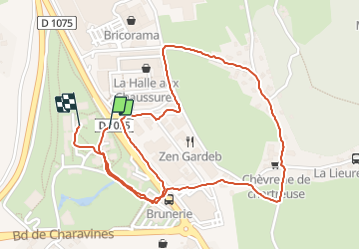

Length
2.9 km

Max alt
410 m

Uphill gradient
45 m
Km-Effort
3.5 km

Min alt
380 m

Downhill gradient
45 m
Boucle
Yes
Creation date :
2021-11-18 13:35:23.091
Updated on :
2021-11-18 14:45:41.17
51m
Difficulty : Easy

FREE GPS app for hiking
 SityTrail
IGN / Geographical institutes
SityTrail Plus
The world is yours!
About
Trail Walking of 2.9 km to be discovered at Auvergne-Rhône-Alpes, Isère, Voiron. This trail is proposed by JPS73.
Positioning
Country:
France
Region :
Auvergne-Rhône-Alpes
Department/Province :
Isère
Municipality :
Voiron
Location:
Unknown
Start:(Dec)
Start:(UTM)
701796 ; 5028670 (31T) N.
Comments