


ste Radegonde

bouscaillou
User
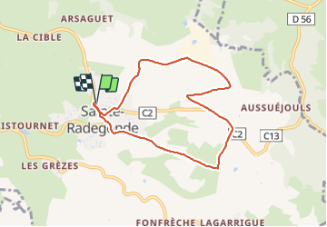

Length
7.6 km

Max alt
673 m

Uphill gradient
117 m
Km-Effort
9.2 km

Min alt
623 m

Downhill gradient
119 m
Boucle
Yes
Creation date :
2021-11-19 08:28:38.684
Updated on :
2021-11-19 10:39:03.147
2h10
Difficulty : Very easy

FREE GPS app for hiking
 SityTrail
IGN / Geographical institutes
SityTrail Plus
The world is yours!
About
Trail Nordic walking of 7.6 km to be discovered at Occitania, Aveyron, Sainte-Radegonde. This trail is proposed by bouscaillou.
Positioning
Country:
France
Region :
Occitania
Department/Province :
Aveyron
Municipality :
Sainte-Radegonde
Location:
Unknown
Start:(Dec)
Start:(UTM)
470134 ; 4909651 (31T) N.
Comments