


NAYEMONT

surceneux
User
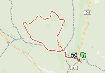

Length
9 km

Max alt
943 m

Uphill gradient
270 m
Km-Effort
12.6 km

Min alt
793 m

Downhill gradient
279 m
Boucle
Yes
Creation date :
2021-11-19 13:59:59.331
Updated on :
2021-11-19 16:56:35.493
1h55
Difficulty : Easy

FREE GPS app for hiking
 SityTrail
IGN / Geographical institutes
SityTrail Plus
The world is yours!
About
Trail Walking of 9 km to be discovered at Grand Est, Vosges, Xonrupt-Longemer. This trail is proposed by surceneux.
Description
AUTOUR DE NAYEMONT
Positioning
Country:
France
Region :
Grand Est
Department/Province :
Vosges
Municipality :
Xonrupt-Longemer
Location:
Unknown
Start:(Dec)
Start:(UTM)
344059 ; 5329332 (32U) N.
Comments