


libin

Airelle
User
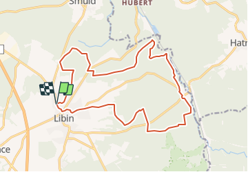

Length
18.2 km

Max alt
509 m

Uphill gradient
445 m
Km-Effort
24 km

Min alt
361 m

Downhill gradient
444 m
Boucle
Yes
Creation date :
2021-11-20 17:04:12.022
Updated on :
2021-11-21 09:09:11.165
5h29
Difficulty : Very difficult

FREE GPS app for hiking
 SityTrail
IGN / Geographical institutes
SityTrail Plus
The world is yours!
About
Trail Walking of 18.2 km to be discovered at Wallonia, Luxembourg, Libin. This trail is proposed by Airelle.
Positioning
Country:
Belgium
Region :
Wallonia
Department/Province :
Luxembourg
Municipality :
Libin
Location:
Unknown
Start:(Dec)
Start:(UTM)
661524 ; 5539443 (31U) N.
Comments