d9820a_085114c115914589a303bb7e9d230e2b

zazibelle
User
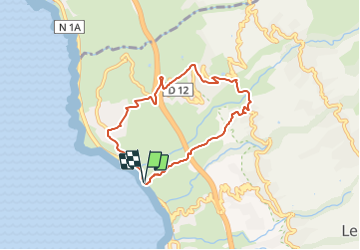

Length
9 km

Max alt
540 m

Uphill gradient
540 m
Km-Effort
16.3 km

Min alt
9 m

Downhill gradient
545 m
Boucle
Yes
Creation date :
2021-11-21 11:20:34.55
Updated on :
2021-11-21 11:22:06.262
3h41
Difficulty : Difficult

FREE GPS app for hiking
 SityTrail
IGN / Geographical institutes
SityTrail Plus
The world is yours!
About
Trail Walking of 9 km to be discovered at Réunion, Unknown, Saint-Leu. This trail is proposed by zazibelle.
Positioning
Country:
France
Region :
Réunion
Department/Province :
Unknown
Municipality :
Saint-Leu
Location:
Unknown
Start:(Dec)
Start:(UTM)
321743 ; 7659677 (40K) S.
Comments