


Saiguède version 2021

pidjam
User
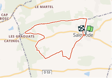

Length
9.1 km

Max alt
310 m

Uphill gradient
173 m
Km-Effort
11.4 km

Min alt
229 m

Downhill gradient
172 m
Boucle
Yes
Creation date :
2021-11-21 13:12:23.309
Updated on :
2021-11-21 16:33:12.047
2h15
Difficulty : Easy

FREE GPS app for hiking
 SityTrail
IGN / Geographical institutes
SityTrail Plus
The world is yours!
About
Trail Walking of 9.1 km to be discovered at Occitania, Haute-Garonne, Saiguède. This trail is proposed by pidjam.
Positioning
Country:
France
Region :
Occitania
Department/Province :
Haute-Garonne
Municipality :
Saiguède
Location:
Unknown
Start:(Dec)
Start:(UTM)
350188 ; 4821158 (31T) N.
Comments