


track

chasle
User
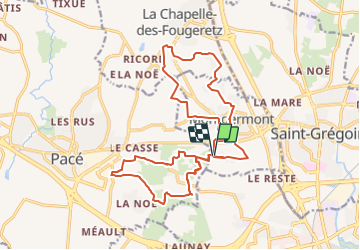

Length
22 km

Max alt
77 m

Uphill gradient
163 m
Km-Effort
24 km

Min alt
41 m

Downhill gradient
163 m
Boucle
Yes
Creation date :
2021-11-22 19:05:07.56
Updated on :
2021-11-22 21:32:01.229
7h16
Difficulty : Easy

FREE GPS app for hiking
 SityTrail
IGN / Geographical institutes
SityTrail Plus
The world is yours!
About
Trail Walking of 22 km to be discovered at Brittany, Ille-et-Vilaine, Montgermont. This trail is proposed by chasle.
Positioning
Country:
France
Region :
Brittany
Department/Province :
Ille-et-Vilaine
Municipality :
Montgermont
Location:
Unknown
Start:(Dec)
Start:(UTM)
595037 ; 5333444 (30U) N.
Comments