


Profondeville/Arbre

geoffrayLayeux
User
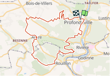

Length
23 km

Max alt
274 m

Uphill gradient
696 m
Km-Effort
32 km

Min alt
79 m

Downhill gradient
696 m
Boucle
Yes
Creation date :
2021-11-22 19:11:00.955
Updated on :
2021-11-22 19:11:58.85
7h20
Difficulty : Very difficult

FREE GPS app for hiking
 SityTrail
IGN / Geographical institutes
SityTrail Plus
The world is yours!
About
Trail Walking of 23 km to be discovered at Wallonia, Namur, Profondeville. This trail is proposed by geoffrayLayeux.
Positioning
Country:
Belgium
Region :
Wallonia
Department/Province :
Namur
Municipality :
Profondeville
Location:
Profondeville
Start:(Dec)
Start:(UTM)
632944 ; 5582317 (31U) N.
Comments