


Montagne de Gache 400 +

claude nier
User
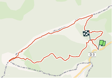

Length
6.4 km

Max alt
1336 m

Uphill gradient
396 m
Km-Effort
11.4 km

Min alt
1029 m

Downhill gradient
306 m
Boucle
No
Creation date :
2021-11-23 09:29:13.137
Updated on :
2021-11-23 15:28:20.454
3h55
Difficulty : Easy

FREE GPS app for hiking
 SityTrail
IGN / Geographical institutes
SityTrail Plus
The world is yours!
About
Trail Walking of 6.4 km to be discovered at Provence-Alpes-Côte d'Azur, Alpes-de-Haute-Provence, Saint-Geniez. This trail is proposed by claude nier.
Description
Petite rando sympa...
Apres 6 mois de Rien !!!
Toujours la Patate !!
Positioning
Country:
France
Region :
Provence-Alpes-Côte d'Azur
Department/Province :
Alpes-de-Haute-Provence
Municipality :
Saint-Geniez
Location:
Unknown
Start:(Dec)
Start:(UTM)
261270 ; 4902321 (32T) N.
Comments