


sortie 23-11-2021

Didier-114
User

Length
9.2 km

Max alt
164 m

Uphill gradient
193 m
Km-Effort
11.8 km

Min alt
82 m

Downhill gradient
194 m
Boucle
Yes
Creation date :
2021-11-23 12:10:48.697
Updated on :
2021-11-23 15:28:49.873
3h17
Difficulty : Difficult

FREE GPS app for hiking
 SityTrail
IGN / Geographical institutes
SityTrail Plus
The world is yours!
About
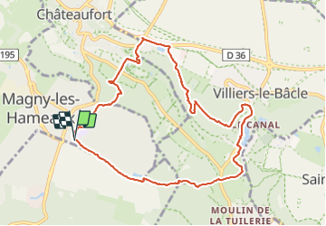
Trail Walking of 9.2 km to be discovered at Ile-de-France, Yvelines, Magny-les-Hameaux. This trail is proposed by Didier-114.
Positioning
Country:
France
Region :
Ile-de-France
Department/Province :
Yvelines
Municipality :
Magny-les-Hameaux
Location:
Unknown
Start:(Dec)
Start:(UTM)
433114 ; 5396745 (31U) N.
Comments