


randogps44-177

chasle
User

Length
22 km

Max alt
94 m

Uphill gradient
203 m
Km-Effort
24 km

Min alt
44 m

Downhill gradient
203 m
Boucle
Yes
Creation date :
2021-11-23 20:14:18.977
Updated on :
2021-12-16 19:04:00.918
5h22
Difficulty : Easy

FREE GPS app for hiking
 SityTrail
IGN / Geographical institutes
SityTrail Plus
The world is yours!
About
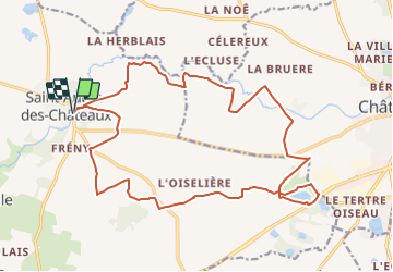
Trail Walking of 22 km to be discovered at Pays de la Loire, Loire-Atlantique, Saint-Aubin-des-Châteaux. This trail is proposed by chasle.
Positioning
Country:
France
Region :
Pays de la Loire
Department/Province :
Loire-Atlantique
Municipality :
Saint-Aubin-des-Châteaux
Location:
Unknown
Start:(Dec)
Start:(UTM)
613809 ; 5286051 (30T) N.
Comments