


auffargis/rambouillet

cemoi
User
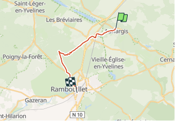

Length
13.1 km

Max alt
188 m

Uphill gradient
113 m
Km-Effort
14.6 km

Min alt
145 m

Downhill gradient
106 m
Boucle
No
Creation date :
2021-11-24 11:41:44.751
Updated on :
2021-11-24 11:46:41.797
3h18
Difficulty : Difficult

FREE GPS app for hiking
 SityTrail
IGN / Geographical institutes
SityTrail Plus
The world is yours!
About
Trail Walking of 13.1 km to be discovered at Ile-de-France, Yvelines, Auffargis. This trail is proposed by cemoi.
Positioning
Country:
France
Region :
Ile-de-France
Department/Province :
Yvelines
Municipality :
Auffargis
Location:
Unknown
Start:(Dec)
Start:(UTM)
417961 ; 5394972 (31U) N.
Comments