


auffargis a Rambouillet

cemoi
User
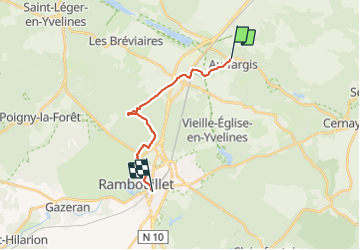

Length
13.4 km

Max alt
188 m

Uphill gradient
128 m
Km-Effort
15 km

Min alt
145 m

Downhill gradient
121 m
Boucle
No
Creation date :
2021-11-24 13:07:52.908
Updated on :
2021-11-24 15:54:11.28
2h42
Difficulty : Difficult

FREE GPS app for hiking
 SityTrail
IGN / Geographical institutes
SityTrail Plus
The world is yours!
About
Trail Walking of 13.4 km to be discovered at Ile-de-France, Yvelines, Auffargis. This trail is proposed by cemoi.
Positioning
Country:
France
Region :
Ile-de-France
Department/Province :
Yvelines
Municipality :
Auffargis
Location:
Unknown
Start:(Dec)
Start:(UTM)
417975 ; 5394969 (31U) N.
Comments