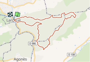
Thaurac depuis Laroque

34christophe
User


4h03
Difficulty : Easy

FREE GPS app for hiking
 SityTrail
IGN / Geographical institutes
SityTrail Plus
The world is yours!
About
Trail On foot of 11.6 km to be discovered at Occitania, Hérault, Laroque. This trail is proposed by 34christophe.
Description
Belle rando sur plateau du Thaurac par Rocher du pin ( très belle vue et endroit agréable pour pique nique ; fait en A/R sur sente peu évidente de quelques minutes, plutôt que par circuit ).
Au point de retour, vers le km7,5, possibilité de continuer en A/R sur la crête : beau point de vue sur promontoire au dessus de Montoulieu, au bout de 20' ; la rando est portée à 15,5km environ ).
Positioning
Comments