
Royat_Paradis

jagarnier
User GUIDE
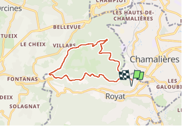


2h15
Difficulty : Easy

FREE GPS app for hiking
 SityTrail
IGN / Geographical institutes
SityTrail Plus
The world is yours!
About
Trail Walking of 7.1 km to be discovered at Auvergne-Rhône-Alpes, Puy-de-Dôme, Royat. This trail is proposed by jagarnier.
Description
Ce circuit est un bol d'air pour de nombreux citadins. A lui seul, il résume le département : la faille de la Limagne, la Tiretaine et sa vallée, une forêt mixte, les eaux thermale de Royat, ... et la ville toute proche.
Photos


Positioning
Comments