


Flassan

rlebasque
User
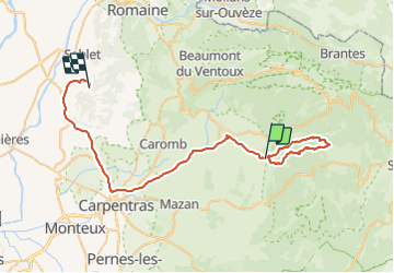

Length
56 km

Max alt
1049 m

Uphill gradient
1075 m
Km-Effort
71 km

Min alt
60 m

Downhill gradient
1194 m
Boucle
No
Creation date :
2021-11-26 08:16:36.608
Updated on :
2021-11-27 09:01:23.863
23h52
Difficulty : Very difficult

FREE GPS app for hiking
 SityTrail
IGN / Geographical institutes
SityTrail Plus
The world is yours!
About
Trail Walking of 56 km to be discovered at Provence-Alpes-Côte d'Azur, Vaucluse, Flassan. This trail is proposed by rlebasque.
Positioning
Country:
France
Region :
Provence-Alpes-Côte d'Azur
Department/Province :
Vaucluse
Municipality :
Flassan
Location:
Unknown
Start:(Dec)
Start:(UTM)
679050 ; 4885108 (31T) N.
Comments