


Les minerais

groslambert
User
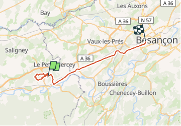

Length
35 km

Max alt
296 m

Uphill gradient
423 m
Km-Effort
40 km

Min alt
230 m

Downhill gradient
385 m
Boucle
No
Creation date :
2021-11-27 08:28:32.842
Updated on :
2021-11-27 11:31:51.45
2h00
Difficulty : Easy

FREE GPS app for hiking
 SityTrail
IGN / Geographical institutes
SityTrail Plus
The world is yours!
About
Trail Nordic walking of 35 km to be discovered at Bourgogne-Franche-Comté, Jura, Ranchot. This trail is proposed by groslambert.
Positioning
Country:
France
Region :
Bourgogne-Franche-Comté
Department/Province :
Jura
Municipality :
Ranchot
Location:
Unknown
Start:(Dec)
Start:(UTM)
706622 ; 5227516 (31T) N.
Comments