


Bondoufle Cyclisme

Lucquiaud
User
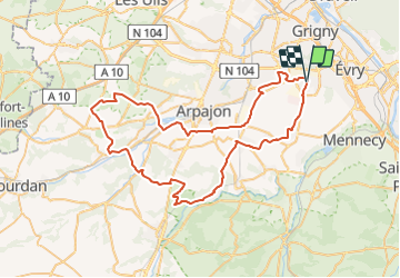

Length
69 km

Max alt
156 m

Uphill gradient
700 m
Km-Effort
78 km

Min alt
51 m

Downhill gradient
700 m
Boucle
Yes
Creation date :
2021-11-29 16:48:57.108
Updated on :
2021-11-30 12:29:19.94
4h42
Difficulty : Very difficult

FREE GPS app for hiking
 SityTrail
IGN / Geographical institutes
SityTrail Plus
The world is yours!
About
Trail Road bike of 69 km to be discovered at Ile-de-France, Essonne, Bondoufle. This trail is proposed by Lucquiaud.
Positioning
Country:
France
Region :
Ile-de-France
Department/Province :
Essonne
Municipality :
Bondoufle
Location:
Unknown
Start:(Dec)
Start:(UTM)
454089 ; 5384709 (31U) N.
Comments