


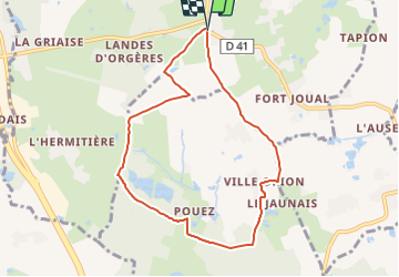
SityTrail - La balade de Pouez

chasle
User

Length
7.6 km

Max alt
104 m

Uphill gradient
77 m
Km-Effort
8.6 km

Min alt
72 m

Downhill gradient
76 m
Boucle
Yes
Creation date :
2021-11-29 19:12:55.484
Updated on :
2021-11-29 19:20:12.793
1h57
Difficulty : Easy

FREE GPS app for hiking
 SityTrail
IGN / Geographical institutes
SityTrail Plus
The world is yours!
About
Trail Walking of 7.6 km to be discovered at Brittany, Ille-et-Vilaine, Orgères. This trail is proposed by chasle.
Positioning
Country:
France
Region :
Brittany
Department/Province :
Ille-et-Vilaine
Municipality :
Orgères
Location:
Unknown
Start:(Dec)
Start:(UTM)
600026 ; 5314628 (30T) N.
Comments