


D16 - GR 10

loic09
User
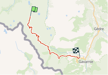

Length
22 km

Max alt
2744 m

Uphill gradient
1026 m
Km-Effort
37 km

Min alt
1495 m

Downhill gradient
1521 m
Boucle
No
Creation date :
2014-12-10 00:00:00.0
Updated on :
2014-12-10 00:00:00.0
7h22
Difficulty : Medium

FREE GPS app for hiking
 SityTrail
IGN / Geographical institutes
SityTrail Plus
The world is yours!
About
Trail Walking of 22 km to be discovered at Occitania, Hautespyrenees, Cauterets. This trail is proposed by loic09.
Description
Passerelle (Refuge de Oulette de Gaube)/Granges de holle

Positioning
Country:
France
Region :
Occitania
Department/Province :
Hautespyrenees
Municipality :
Cauterets
Location:
Unknown
Start:(Dec)
Start:(UTM)
734131 ; 4743576 (30T) N.
Comments