


2021 11 30 Argancy BF

bstebe
User
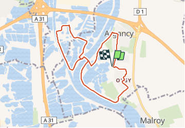

Length
8.7 km

Max alt
175 m

Uphill gradient
67 m
Km-Effort
9.6 km

Min alt
155 m

Downhill gradient
67 m
Boucle
Yes
Creation date :
2021-11-30 12:52:50.617
Updated on :
2021-11-30 15:08:49.324
2h02
Difficulty : Medium

FREE GPS app for hiking
 SityTrail
IGN / Geographical institutes
SityTrail Plus
The world is yours!
About
Trail Walking of 8.7 km to be discovered at Grand Est, Moselle, Argancy. This trail is proposed by bstebe.
Positioning
Country:
France
Region :
Grand Est
Department/Province :
Moselle
Municipality :
Argancy
Location:
Unknown
Start:(Dec)
Start:(UTM)
295954 ; 5452207 (32U) N.
Comments