


13 Vitrolles grenadier salvarenque antennes citernes

Nathy8913
User
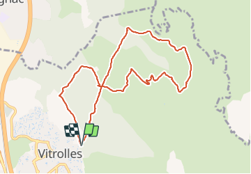

Length
10.6 km

Max alt
220 m

Uphill gradient
131 m
Km-Effort
12.3 km

Min alt
158 m

Downhill gradient
132 m
Boucle
Yes
Creation date :
2021-12-02 12:49:23.315
Updated on :
2021-12-02 15:25:58.095
2h35
Difficulty : Easy

FREE GPS app for hiking
 SityTrail
IGN / Geographical institutes
SityTrail Plus
The world is yours!
About
Trail Walking of 10.6 km to be discovered at Provence-Alpes-Côte d'Azur, Bouches-du-Rhône, Vitrolles. This trail is proposed by Nathy8913.
Positioning
Country:
France
Region :
Provence-Alpes-Côte d'Azur
Department/Province :
Bouches-du-Rhône
Municipality :
Vitrolles
Location:
Unknown
Start:(Dec)
Start:(UTM)
682320 ; 4814455 (31T) N.
Comments