


Croix Valmer oppidum Montjean

bernir
User
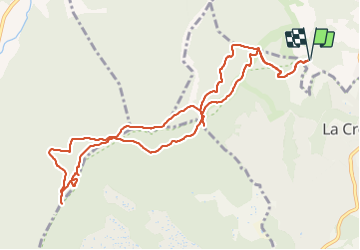

Length
12.7 km

Max alt
453 m

Uphill gradient
475 m
Km-Effort
19 km

Min alt
88 m

Downhill gradient
476 m
Boucle
Yes
Creation date :
2021-12-02 08:56:26.218
Updated on :
2021-12-06 06:52:15.436
5h44
Difficulty : Difficult

FREE GPS app for hiking
 SityTrail
IGN / Geographical institutes
SityTrail Plus
The world is yours!
About
Trail Walking of 12.7 km to be discovered at Provence-Alpes-Côte d'Azur, Var, Gassin. This trail is proposed by bernir.
Positioning
Country:
France
Region :
Provence-Alpes-Côte d'Azur
Department/Province :
Var
Municipality :
Gassin
Location:
Unknown
Start:(Dec)
Start:(UTM)
301486 ; 4787769 (32T) N.
Comments