


pont de reynes 2

Phidel66
User
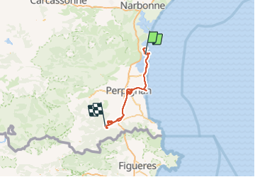

Length
308 km

Max alt
305 m

Uphill gradient
2618 m
Km-Effort
342 km

Min alt
-3 m

Downhill gradient
2483 m
Boucle
No
Creation date :
2021-10-24 12:48:54.864
Updated on :
2021-12-02 16:33:37.497
69h41
Difficulty : Very easy

FREE GPS app for hiking
 SityTrail
IGN / Geographical institutes
SityTrail Plus
The world is yours!
About
Trail Walking of 308 km to be discovered at Occitania, Aude, Leucate. This trail is proposed by Phidel66.
Positioning
Country:
France
Region :
Occitania
Department/Province :
Aude
Municipality :
Leucate
Location:
Unknown
Start:(Dec)
Start:(UTM)
501982 ; 4750245 (31T) N.
Comments