


Là Maït d'Amunt

orsel
User GUIDE
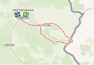

Length
14.8 km

Max alt
2787 m

Uphill gradient
1079 m
Km-Effort
29 km

Min alt
1682 m

Downhill gradient
1097 m
Boucle
Yes
Creation date :
2021-12-03 08:21:25.183
Updated on :
2021-12-03 17:29:06.536
5h55
Difficulty : Difficult

FREE GPS app for hiking
 SityTrail
IGN / Geographical institutes
SityTrail Plus
The world is yours!
About
Trail Touring skiing of 14.8 km to be discovered at Provence-Alpes-Côte d'Azur, Hautes-Alpes, Abriès-Ristolas. This trail is proposed by orsel.
Description
le 3 décembre 2021
Positioning
Country:
France
Region :
Provence-Alpes-Côte d'Azur
Department/Province :
Hautes-Alpes
Municipality :
Abriès-Ristolas
Location:
Unknown
Start:(Dec)
Start:(UTM)
337493 ; 4964669 (32T) N.
Comments