


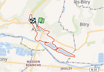
Attichy

pascha
User

Length
7.8 km

Max alt
66 m

Uphill gradient
58 m
Km-Effort
8.6 km

Min alt
33 m

Downhill gradient
63 m
Boucle
Yes
Creation date :
2021-12-05 08:02:54.0
Updated on :
2021-12-05 10:07:41.049
2h03
Difficulty : Very easy

FREE GPS app for hiking
 SityTrail
IGN / Geographical institutes
SityTrail Plus
The world is yours!
About
Trail Walking of 7.8 km to be discovered at Hauts-de-France, Oise, Attichy. This trail is proposed by pascha.
Positioning
Country:
France
Region :
Hauts-de-France
Department/Province :
Oise
Municipality :
Attichy
Location:
Unknown
Start:(Dec)
Start:(UTM)
503494 ; 5473346 (31U) N.
Comments