


Forêt d Anlier

Airelle
User
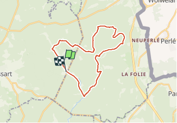

Length
14.6 km

Max alt
517 m

Uphill gradient
241 m
Km-Effort
17.9 km

Min alt
421 m

Downhill gradient
245 m
Boucle
No
Creation date :
2021-12-05 09:01:07.0
Updated on :
2021-12-05 19:15:54.913
3h18
Difficulty : Difficult

FREE GPS app for hiking
 SityTrail
IGN / Geographical institutes
SityTrail Plus
The world is yours!
About
Trail Walking of 14.6 km to be discovered at Wallonia, Luxembourg, Martelange. This trail is proposed by Airelle.
Positioning
Country:
Belgium
Region :
Wallonia
Department/Province :
Luxembourg
Municipality :
Martelange
Location:
Martelange
Start:(Dec)
Start:(UTM)
693722 ; 5519661 (31U) N.
Comments