


Herbiester/portes des Hautes Fagnes

geoffrayLayeux
User
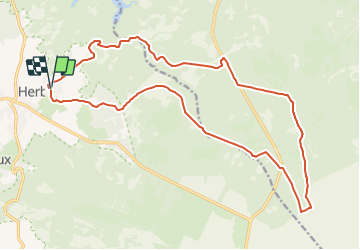

Length
19.5 km

Max alt
606 m

Uphill gradient
383 m
Km-Effort
25 km

Min alt
310 m

Downhill gradient
380 m
Boucle
Yes
Creation date :
2021-12-05 12:35:59.496
Updated on :
2021-12-05 12:37:00.831
5h35
Difficulty : Very difficult

FREE GPS app for hiking
 SityTrail
IGN / Geographical institutes
SityTrail Plus
The world is yours!
About
Trail Walking of 19.5 km to be discovered at Wallonia, Liège, Jalhay. This trail is proposed by geoffrayLayeux.
Positioning
Country:
Belgium
Region :
Wallonia
Department/Province :
Liège
Municipality :
Jalhay
Location:
Unknown
Start:(Dec)
Start:(UTM)
710956 ; 5605343 (31U) N.
Comments