


Eupen/foret ducale et Hautes Fagnes de l'Est

geoffrayLayeux
User
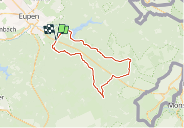

Length
24 km

Max alt
566 m

Uphill gradient
405 m
Km-Effort
30 km

Min alt
338 m

Downhill gradient
400 m
Boucle
Yes
Creation date :
2021-12-05 13:12:54.385
Updated on :
2021-12-05 13:14:04.293
6h47
Difficulty : Very difficult

FREE GPS app for hiking
 SityTrail
IGN / Geographical institutes
SityTrail Plus
The world is yours!
About
Trail Walking of 24 km to be discovered at Wallonia, Liège, Eupen. This trail is proposed by geoffrayLayeux.
Positioning
Country:
Belgium
Region :
Wallonia
Department/Province :
Liège
Municipality :
Eupen
Location:
Eupen (Altgemeinde)
Start:(Dec)
Start:(UTM)
292625 ; 5610473 (32U) N.
Comments