Trail On foot Thomery - randogps77-83 - Photo

Club randonnées SERVON

© OpenStreetMap contributors
Length
Length
25 km
Max alt
Max alt
138 m
Uphill gradient
Uphill gradient
386 m
Km-Effort
Km-Effort  
30 km
Min alt
Min alt
43 m
Downhill gradient
Downhill gradient
388 m
Boucle
Boucle
Yes
Creation date :
2021-12-05 14:11:46.797
Updated on :
2022-02-08 11:19:06.2

(1 Reviews)

On foot
On foot
6h18
Difficulty : Difficult

Scan this QR Code to open this trail in the SityTrail application

FREE GPS app for hiking

Logo SityTrail SityTrail

IGN / Geographical institutes

Download SityTrail from the App Store Download SityTrail from Google Play

Logo SityTrail SityTrail World

The world is yours!

Download SityTrail from the App Store Download SityTrail from Google Play Download SityTrail on Huawei AppGallery

About

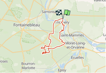
Trail On foot of 25 km to be discovered at Ile-de-France, Seine-et-Marne, Thomery. This trail is proposed by Les 1000 pattes.

Description

Parking Rue des Bains du Roy à Thomery (près de la Seine)
Trajet Servon-->Parking (44km: 44mn)

Elevation profile

Positioning

Country:
France
Region :
Ile-de-France
Department/Province :
Seine-et-Marne
Municipality :
Thomery
Location:
Unknown
Start:(UTM)
484228 ; 5362275 (31U) N.

Comments

Please log in to post a review or rate the element


Trails nearby

Trail Walking Champagne-sur-Seine - GLM-150507 - Champagne - Photo
Walking
randodan

Walking

Easy
(1)
Champagne-sur-Seine, Ile-de-France, Seine-et-Marne, France
17.3 km | 20 km-effort
4h 20min
Yes
Trail Walking Fontainebleau - Rocher Fourceau-Petit Mont Chauvet SR210523Ve?? fmg - Photo
Walking
fmg

Walking

Very difficult
(1)
Fontainebleau, Ile-de-France, Seine-et-Marne, France
19.5 km | 24 km-effort
5h 27min
Yes
Trail Other activity Thomery - forêt de fontainebleau  - Photo
Other activity
bellicaud

Other activity

Medium
(1)
Thomery, Ile-de-France, Seine-et-Marne, France
20 km | 23 km-effort
5h 40min
Yes
Trail On foot Saint-Mammès - Batellerie et foret - Photo
On foot
PRO

On foot

Easy
Saint-Mammès, Ile-de-France, Seine-et-Marne, France
8.6 km | 9.9 km-effort
2h 14min
Yes
Trail On foot Fontainebleau - Sentier Denecourt-Colinet 14 - Photo
On foot
PRO

On foot

Easy
Fontainebleau, Ile-de-France, Seine-et-Marne, France
5.3 km | 6.5 km-effort
1h 28min
No
Trail On foot Samois-sur-Seine - Sentier Denecourt-Colinet 15 - Photo
On foot
PRO

On foot

Easy
Samois-sur-Seine, Ile-de-France, Seine-et-Marne, France
7.8 km | 8.9 km-effort
2h 1min
No
Trail Walking Fontainebleau - Fontainebleau tour est - Photo
Walking

Walking

Difficult
(4)
Fontainebleau, Ile-de-France, Seine-et-Marne, France
22 km | 27 km-effort
6h 10min
Yes
Trail Walking Avon - Boucle depuis gare de Fontainebleau - Photo
Walking
onftest

Walking

Medium
(1)
Avon, Ile-de-France, Seine-et-Marne, France
16.8 km | 21 km-effort
4h 33min
Yes
Trail Walking Fontainebleau - Fait 02/23 TB  Malmontagne + Haut Mont +  Long Rocher  - Photo
Walking
jl77130

Walking

Medium
Fontainebleau, Ile-de-France, Seine-et-Marne, France
9.8 km | 13.2 km-effort
2h 53min
Yes


Close
My subscriptions