


ReConnaissance chemin poissonnier

gerard.colonna
User
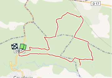

Length
11.8 km

Max alt
278 m

Uphill gradient
136 m
Km-Effort
13.6 km

Min alt
231 m

Downhill gradient
135 m
Boucle
Yes
Creation date :
2021-12-06 08:52:54.0
Updated on :
2021-12-06 12:02:22.292
2h41
Difficulty : Easy

FREE GPS app for hiking
 SityTrail
IGN / Geographical institutes
SityTrail Plus
The world is yours!
About
Trail Walking of 11.8 km to be discovered at Provence-Alpes-Côte d'Azur, Bouches-du-Rhône, Coudoux. This trail is proposed by gerard.colonna.
Positioning
Country:
France
Region :
Provence-Alpes-Côte d'Azur
Department/Province :
Bouches-du-Rhône
Municipality :
Coudoux
Location:
Unknown
Start:(Dec)
Start:(UTM)
681528 ; 4826360 (31T) N.
Comments