


BAISSE DE CANGELARD au DEPART DE PELASQUE (AUDA)

Benteux
User
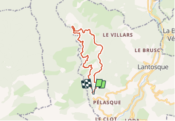

Length
13.2 km

Max alt
1202 m

Uphill gradient
704 m
Km-Effort
23 km

Min alt
677 m

Downhill gradient
706 m
Boucle
Yes
Creation date :
2021-12-07 16:19:51.117
Updated on :
2021-12-07 16:22:37.254
5h07
Difficulty : Medium

FREE GPS app for hiking
 SityTrail
IGN / Geographical institutes
SityTrail Plus
The world is yours!
About
Trail Walking of 13.2 km to be discovered at Provence-Alpes-Côte d'Azur, Maritime Alps, Lantosque. This trail is proposed by Benteux.
Positioning
Country:
France
Region :
Provence-Alpes-Côte d'Azur
Department/Province :
Maritime Alps
Municipality :
Lantosque
Location:
Unknown
Start:(Dec)
Start:(UTM)
361262 ; 4868789 (32T) N.
Comments