


Gazeran chateau rambouillet

topophil
User
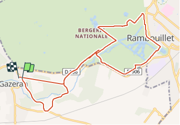

Length
11.9 km

Max alt
175 m

Uphill gradient
153 m
Km-Effort
13.9 km

Min alt
138 m

Downhill gradient
153 m
Boucle
Yes
Creation date :
2021-12-08 08:27:22.021
Updated on :
2021-12-08 11:11:23.831
2h27
Difficulty : Difficult

FREE GPS app for hiking
 SityTrail
IGN / Geographical institutes
SityTrail Plus
The world is yours!
About
Trail Walking of 11.9 km to be discovered at Ile-de-France, Yvelines, Gazeran. This trail is proposed by topophil.
Positioning
Country:
France
Region :
Ile-de-France
Department/Province :
Yvelines
Municipality :
Gazeran
Location:
Unknown
Start:(Dec)
Start:(UTM)
409760 ; 5387713 (31U) N.
Comments