Trail On foot Villefranche-d'Albigeois - 2021-12-09_09h07m15_Cirkwi-Le_Sentier_de_Calle - Photo

2021-12-09_09h07m15_Cirkwi-Le_Sentier_de_Calle

 tercla
tercla

User

© OpenStreetMap contributors
Length
Length
7.2 km
Max alt
Max alt
450 m
Uphill gradient
Uphill gradient
207 m
Km-Effort
Km-Effort  
9.9 km
Min alt
Min alt
335 m
Downhill gradient
Downhill gradient
206 m
Boucle
Boucle
Yes
Creation date :
2021-12-09 08:07:15.676
Updated on :
2021-12-09 16:16:33.913

(0 Reviews)

On foot
On foot
2h15
Difficulty : Easy
Walking
Walking
2h15
Difficulty : Medium

Scan this QR Code to open this trail in the SityTrail application

FREE GPS app for hiking

Logo SityTrail SityTrail

IGN / Geographical institutes

Download SityTrail from the App Store Download SityTrail from Google Play

Logo SityTrail SityTrail World

The world is yours!

Download SityTrail from the App Store Download SityTrail from Google Play Download SityTrail on Huawei AppGallery

About

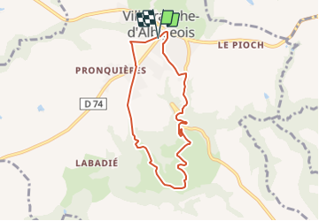
Trail On foot of 7.2 km to be discovered at Occitania, Tarn, Villefranche-d'Albigeois. This trail is proposed by tercla.

Description

Les paysages du Villefranchois sont composés de larges vallées et de beaux plateaux. Le climat est plutôt tempéré, méditerranéen sous l’influence du vent d’autan, atlantique sous les vents dominants d’ouest.Le sentier dit de «Calle» vous promènera tour à tour au bord de l’Assou, à Calle, puis sur le plateau, à «la Sigaudié» où vous attend une superbe vue panoramique sur Villefranche et sa campagne environnante. Vous redescendrez jusqu’au ruisseau, au Moulin de Bonnal. Il existait déjà en 1789 et ses immenses meules actionnées par la force de l’eau permettaient aux paysans du secteur de moudre leurs divers grains et de s’approvisionner en farine.  En occitan le mot «cala» désigne un endroit abrité. Peut-être est-il à l’origine du nom du lieu.

Elevation profile

Positioning

Country:
France
Region :
Occitania
Department/Province :
Tarn
Municipality :
Villefranche-d'Albigeois
Location:
Unknown
Start:(UTM)
446142 ; 4860478 (31T) N.

Trails nearby

Trail Walking Bellegarde-Marsal - Marsal : le méandre de Marsal - Photo
Walking
tercla

Walking

Medium
(1)
Bellegarde-Marsal, Occitania, Tarn, France
10.3 km | 14.6 km-effort
3h 0min
Yes
Trail Walking Villefranche-d'Albigeois - Les méandres du Tarn - Photo
Walking
tracegps

Walking

Difficult
Villefranche-d'Albigeois, Occitania, Tarn, France
13.4 km | 18.8 km-effort
4h 30min
Yes
Trail Car Paulinet - Voiture Poisat - Photo
Car
pb07

Car

Very easy
Paulinet, Occitania, Tarn, France
524 km | 606 km-effort
7h 11min
No
Trail Walking Bellegarde-Marsal - Sentier des 3 ruisseaux  - Photo
Walking
DC76DC

Walking

Easy
Bellegarde-Marsal, Occitania, Tarn, France
10.5 km | 13.6 km-effort
2h 56min
Yes
Trail Walking Mouzieys-Teulet - Boucle Lou Cami de Theoullet / Les trois Ruisseaux - Photo
Walking
tercla

Walking

Easy
Mouzieys-Teulet, Occitania, Tarn, France
18 km | 23 km-effort
7h 16min
Yes
Trail Walking Bellegarde-Marsal - Les 3 ruisseaux variante  - Photo
Walking
jfpascal

Walking

Easy
Bellegarde-Marsal, Occitania, Tarn, France
10.7 km | 14.3 km-effort
2h 40min
Yes
Trail On foot Terre-de-Bancalié - track - Photo
On foot
tercla

On foot

Easy
(1)
Terre-de-Bancalié, Occitania, Tarn, France
9.4 km | 12.8 km-effort
Unknown
Yes
Trail Walking Terre-de-Bancalié - Entre vallons et colines - Photo
Walking
CANON2

Walking

Easy
Terre-de-Bancalié, Occitania, Tarn, France
10.1 km | 13.8 km-effort
2h 40min
Yes


Close
My subscriptions