


Villers la Ville

jacthiry
User
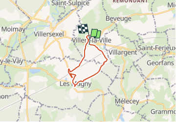

Length
8.7 km

Max alt
317 m

Uphill gradient
119 m
Km-Effort
10.3 km

Min alt
273 m

Downhill gradient
128 m
Boucle
No
Creation date :
2021-12-09 13:13:20.519
Updated on :
2021-12-09 21:37:04.412
2h18
Difficulty : Medium

FREE GPS app for hiking
 SityTrail
IGN / Geographical institutes
SityTrail Plus
The world is yours!
About
Trail Walking of 8.7 km to be discovered at Bourgogne-Franche-Comté, Haute-Saône, Villers-la-Ville. This trail is proposed by jacthiry.
Positioning
Country:
France
Region :
Bourgogne-Franche-Comté
Department/Province :
Haute-Saône
Municipality :
Villers-la-Ville
Location:
Unknown
Start:(Dec)
Start:(UTM)
309039 ; 5268920 (32T) N.
Comments