


2021-12-10_20h05m13_activity_7894698426

oliviergau
User
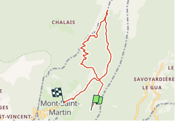

Length
8.8 km

Max alt
1628 m

Uphill gradient
745 m
Km-Effort
19.6 km

Min alt
756 m

Downhill gradient
1006 m
Boucle
No
Creation date :
2021-12-10 19:05:14.604
Updated on :
2021-12-10 19:05:15.707

FREE GPS app for hiking
 SityTrail
IGN / Geographical institutes
SityTrail Plus
The world is yours!
About
Trail of 8.8 km to be discovered at Auvergne-Rhône-Alpes, Isère, Mont-Saint-Martin. This trail is proposed by oliviergau.
Positioning
Country:
France
Region :
Auvergne-Rhône-Alpes
Department/Province :
Isère
Municipality :
Mont-Saint-Martin
Location:
Unknown
Start:(Dec)
Start:(UTM)
710648 ; 5016518 (31T) N.
Comments