


hauts de Cabrières- ledenon château

rando30129
User
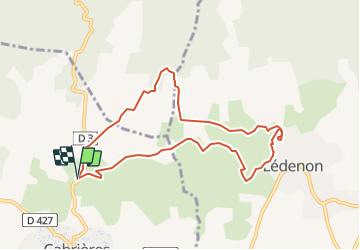

Length
9.1 km

Max alt
211 m

Uphill gradient
126 m
Km-Effort
10.8 km

Min alt
146 m

Downhill gradient
126 m
Boucle
Yes
Creation date :
2021-12-11 14:49:05.35
Updated on :
2022-01-10 18:47:45.263
2h12
Difficulty : Easy

FREE GPS app for hiking
 SityTrail
IGN / Geographical institutes
SityTrail Plus
The world is yours!
About
Trail Walking of 9.1 km to be discovered at Occitania, Gard, Cabrières. This trail is proposed by rando30129.
Positioning
Country:
France
Region :
Occitania
Department/Province :
Gard
Municipality :
Cabrières
Location:
Unknown
Start:(Dec)
Start:(UTM)
618221 ; 4863276 (31T) N.
Comments